• I want to thank all the members that have upgraded your accounts. I truly appreciate your support of the site monetarily. Supporting the site keeps this site up and running as a lot of work daily goes on behind the scenes. Click to Support Signs101 ...

need help "slicing" a 3D file in Enroute

iSign

New Member
I know I can do the kind of slicing that will make several tiers of routed work that stack up higher than your gantry clearance...

but that is NOT what I want to do... my project is a bit more obscure I fear & I don't know where to begin looking for a software solution besides asking here (or by asking Enroute)...

what I want to do is generate vertical slices like in a loaf of bread!
The reason I want to do this is to make a sculpture out of a series of 2D routed slices of the 3d file for the island of Maui. By "2D slices" I just mean a simple profile cut with an end mill tool.

In a relatively short time frame, I could rout the profile of this island in 8' to 10' long boards, at about 8" in height at the summit of Haleakala. (I wrote "boards", but have even thought of using 1/4" clear acrylic too)

Once I generate just enough slices to have 24 or so parallel profile cuts, each about 4" apart, I can produce an 8' long scale model of the island that will provide enough accurate surface contour to staple on some wire mesh for a paper mâché or fiberglass sculpture.

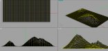
The file I am working with has been converted from a "digital elevation model" (DEM file) to a .tiff file that communicates 3D height data using grayscale shades that represent sea level as black, and the high point (Haleakala) as white. Every other elevation is scaled with the appropriate shade of gray.

Here's one draft of how many slices I could cut. I plan to interlock X-axis slices, and Y-axis slices by cutting slots every 4" up from the bottom of the X-axis slices, and the tops of the Y-axis ones...

I want to display the framework at a 4 day arts festival, starting 12 days from now, possibly as an interactive display where spectator participation results in group application of paper mâché materials to complete the sculpture. Upon drying I could have a few local mural artists help me paint it with a Google Earth photo as a guide...

I am just about crazy enough to tackle this project, and it's challenging time line, if I could only figure out an easy way to program all the file slices!


48x84_MAUI_GRID.jpg
 

GAC05

Quit buggin' me
Hey Doug.
Are you wanting to slice the island into profiles from left to right based on your attached pic? Or you want the slice profiles from the lowest elevation (sea level?) to the top of the mountain (like contour lines on a geo map)?

wayne k
guam usa
 

iSign

New Member
left to right, so they will all have flat bottom edges, that could seat in a gridwork of notches cut into a 5' x 10' base, routed to the the shape of the island, with grooves matching the grids in my image... and they will all have the topographically correct profile of the island, to scale, at that specific slice...

...and in addition to the left to right slices, I will also need to cut top to bottom slices too!
 

GAC05

Quit buggin' me
Got it,
where to get the DEM or tiff of the island?
I can't help with enroute (don't own it) but it seems like I could slice the dem or tiff height map into sections and pull a vector path off the resulting edges at each break.

wayne k
guam usa

> edit<
Found the tiff - gotta run home, but will look at this in the morning, if no one has the "easy button" way posted I'll see if I can do it.

whk
 
Last edited:

John L

New Member
Yes, I also dont use enroute and I'm sure there there must be an easier way but we have done this by just toolpathing the actual 3D slice method you first mentioned. Then either selecting, drawing, or tracing a vector from just the resulting outside profiles of the individual 3D slices (with software previously set to slice @ 4" intervals). We use Aspire and I cant fully remember how I nabbed the vector profile of each slice even but we ended up just as you described.
 

signage

New Member
Doug isn't what you are trying to do tiling?

Does Enroute allow you to tile the tool paths?

And all you need to do is add the interlocking parts and tool paths.
 

signage

New Member
Doug I also found this it may help you "By selecting the Clip Toolpath to Plate located in Setup/Preferences/General tab you can output only the portion of a toolpath that is inside the plate, making separate output files for each plate section."
 

artbot

New Member
if the dem is importable in a 3d program (like rhino). i'd just import it and boolean the part into the slices. then just export the curves to dxf.
 

iSign

New Member
Just getting back to a new day...
Will post more later...

Artbot. I don't have rhino, but if you think it will do this, are you able to run a test?
I converted my DEM files for the islands years ago... and have only used the resulting ,tiff files since then. I will hunt down the DEM to send you if you want to try a test slice..

Brian, after a coffee I'll read your posts again... and everyone else's... but so far I think the ideas posted would be more on track for isolating, & then 3D routing sections of the surface contour (within the plate) and then 3D routing the next adjacent section of the "surface" that my bitmap has been applied to. If time and money were no object, I would love to create a large Maui Sculpture this way... but for this one. I need simple 2D profile vectors at each slice.

As I said... I haven't had my coffee... so I'm going to study these replies again... Thanks for all the input...

Wayne, I started pursuing an idea much like yours and I have a dozen parallel slices of the .tiff file, all extracted at even spacing intervals sufficient to produce the look I'm after, but I stopped short of trying to process them in Enroute because it seems that I have to specify my max height, and the program spreads the grayscale range out to span up to the height I assign... which is fine for the whole island because I know the height at the summit and can determine my caked down height from that... But I don't know the height of these random slices...

plus, this idea the way I pictured it anyway. would be a rather crude way of generating a 3D file for each slice, just so I could take a screenshot of the 3D rendering and vector use that...

I'm holding out for the easy button way :)
 

iSign

New Member
I think paneling it is what Brian is suggesting too but paneling it just gives me 3D segments,

I can see how that could be a step closer, with less work then reprocessing the bitmap slices I was writing Wayne about, and should maintain the relative heights... but I still hope to find a software solution that won't result in my relying on vectorizing screenshots of a 3D rendering... because I have super-space-age accuracy embedded in the source file... so it would seem a shame to downgrade that degree of topographical accuracy IF I don't have to... although maybe ill have to...

I have techs at Enroute looking at this too now...
 

Techman

New Member
Draw a bound, vector or whatever they call it box in enroute
set the tool paths within the box.
copy box, paste box, move it over
set another tool path.
rinse repeat.

edited
OOps forgot a step

click box, click vector, clear area outside of box. Leaves you with a profile just like u want.
 

GAC05

Quit buggin' me
I think I have a solution for you Doug.
The result is attached.

In rhino I create a single nurbs surface from the height map.
Create an array of straight curves in the top view (30 slices)
Project the curves onto the surface.
Those yellow curves can be exported as 2d ai/eps paths.

To make these usable I think we would need:
1. An outline of the island (vector path) to be used as a trim curve to get the shape of the island at sea level and not a rectangle.
2. The actual height of the mountains in proportion to the length and width of the island. I just guessed and made them tall to show what the slice curves would look like.
3. The direction you want the slices to lay over the island
4. The detail you want in each profile curve - I used 300x300 sample points for this height map.
5. Color code the paths to id their order
6. Once exported you'd need to open them in Illy or Corel and close the bottoms to get a complete closed paths.

Took longer to find the Maui map and write this up than to figure it out.

wayne k
guam usa
 

Attachments

  • maui_slices.jpg
    maui_slices.jpg
    140.6 KB · Views: 205

iSign

New Member
Wayne,
As stated in my private message, that looks like you have an equally good (or perhaps better) program to get the job done in... but more importantly, you seem to know a way to do it in Rhino, and I still don't know how to do it in Enroute... so I will continue the more detailed discussions by email, but thanks for offering to help me get some file slicing done... I can't wait to start. Shop closes in an hour, so i will be trying to get a number of decisions made, and dimensions or files sent to you!
 

GAC05

Quit buggin' me
Good deal.
Lunch break here so I'm posting and tracking a package that is taking a round the world tour via UPS.

wayne k
guam usa
 

iSign

New Member
what I want to do is generate vertical slices like in a loaf of bread!

Techman,
I don't know if I explained it as well as i hoped, but if you imagine slicing down through a model of the island, I want very narrow slices that have no 3D contour on the surface, just a simple cross-section profile, but another similar cross-section every 4" to 6", and the same series of slices again on the opposing (90 degree apart) axis
 

iSign

New Member
this is distorted, but it's still cool, so thought I'd share it...
someday I would like to create a model of the islands with a 3D sea floor like this:

hawaiian_islands_map_1280x960.jpg
 

iSign

New Member
oh yeah, by the way... for those who may not have seen it, here is what I created with that file a few years back.. and I have also made a mold of it & reproduced the sculpture with a faux bronze finish.


or...

 
Top